New North Carolina Congressional Map Splits Relatively Few Counties and Municipalities
Published November 25, 2021
By Andy Jackson
Not splitting political units (counties, municipalities, and precincts) was part of the criteriaadopted by the General Assembly at the start of the redistricting process.
Counties How does the number of split counties in the new districts compare to previous rounds of redistricting? To find out, I compared it to every congressional map available for comparison at the General Assembly’s redistricting page. The complete list includes four decennial maps, which must be drawn after the US census every ten years (1992, 2001, 2011, 2021), and four court-ordered maps (1997, 1998, 2016, 2019).
As seen in Table 1, the 2021 map has 11 split counties. That is considerably lower than any of the other maps for which data is available. It is also lower than all but one of the court-ordered maps.
Table 1: Number of split counties in eight redistricting maps
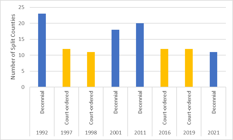
Data source: North Carolina General Assembly
When looking at counties that were split more than once, the latest map also fares well. Three counties are split more than once in the current map, the fewest of any of the past four decennial maps. There were seven counties split more than once in the 1992 map, four in the 2001 map, and eight in the 2011 map. There were no counties split more than once in any of the court-ordered maps.
Municipalities and Precincts Keeping municipalities whole is a mark of good redistricting. Like counties, they are political subdivisions of the state that are natural communities of interest. Conversely, splitting municipalities is a mark of gerrymandering. Similarly, splitting precincts (or voting tabulation districts) should also be kept to a minimum
We only have data on municipality and precinct splits from 2001 through 2021.
The 2021 map has the fewest municipality splits of any map for which data is available (see Table 2). Its 42 split municipalities are fewer than either of the two other decennial maps or the two court-ordered maps available for data.
Table 2: Number of split municipalities in five redistricting maps
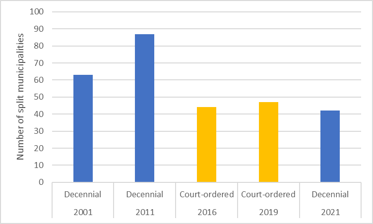
Data source: North Carolina General Assembly
The story on split precincts is a little different. The number of split precincts in the 2021 map is the second-highest of the five maps for which data is available (see Table 3). However, it is not unusually large, especially compared to the 2011 map.
Table 3: Number of split precincts in five redistricting maps
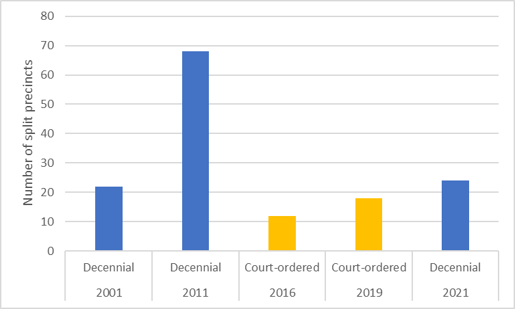
Data source: North Carolina General Assembly
So, by objective measures of split political units, the new congressional map is as good or better than most other maps drawn over the past several decades.